Hurghada is defined as a coastal city on Egypt's Red Sea coast, serving as the largest city and capital of the Red Sea Governorate. The city stretches close to 40 km along the shoreline, making it one of the longest resort strips in the Middle East. Its position between the Red Sea Mountains to the west and the open sea to the east creates a distinct geography that directly shapes how you travel, where you stay, and what you can do. Understanding the Hurghada Red Sea location explained in full gives you a real advantage when planning your trip.
What are the exact geographic coordinates and boundaries of Hurghada?
Hurghada sits at approximately 27.26°N latitude and 33.81°E longitude. Those coordinates place it roughly midway along Egypt's Red Sea coastline, well south of the Suez Canal and north of the more remote resort areas near Marsa Alam.
The city's boundaries follow clear natural and administrative lines. To the north lies Ras Gharib, an industrial town known for oil production. To the south sits Safaga, a quieter port city with its own beaches and dive sites. The eastern boundary is the Red Sea coast itself, and to the west, the Red Sea Mountains form a dramatic natural wall that shapes the local climate and limits westward expansion.
| Direction | Boundary |
|---|---|
| North | Ras Gharib |
| South | Safaga |
| East | Red Sea coastline |
| West | Red Sea Mountains |
Offshore, the Giftun Islands sit within easy boat range of the city center. Big Giftun and Little Giftun are the two main islands, and both fall within the protected Giftun Islands National Park. They are the primary destination for most snorkeling and beach excursion boats departing from Hurghada's marina.
Pro Tip: When searching a Hurghada Red Sea map, zoom out to include Ras Gharib in the north and Safaga in the south. That full view gives you the real scale of the city and its neighboring areas, which matters when booking transfers or day trips.
How does Hurghada fit within the larger Red Sea region?
Egypt's Red Sea coastline extends from the Gulf of Suez in the north all the way down to the Sudanese border in the south. Hurghada sits in the northern third of that stretch, which is why it receives the most direct flight traffic and the highest volume of international visitors.
The broader Red Sea region includes several distinct resort cities, each with its own character:
- Sharm El Sheikh sits on the Sinai Peninsula across the Gulf of Aqaba. It is technically on the Red Sea but separated from Hurghada by the Gulf of Suez. Traveling between the two cities requires either a long drive around the Gulf or a ferry crossing.
- El Gouna is a planned resort town located just 23 km north of Hurghada. It operates as a self-contained community with its own lagoons, airport access, and real estate market.
- Sahl Hasheesh lies about 18 km south of Hurghada's city center. It is a gated resort zone with high-end properties and a quieter beach environment.
- Soma Bay sits roughly 45 km south of Hurghada and is known for its golf course and upscale hotels.
- Marsa Alam is approximately 220 km south of Hurghada and appeals to divers seeking less crowded reefs.
Hurghada's position makes it the natural anchor for the northern Red Sea coast. Travelers who base themselves in Hurghada can reach El Gouna, Sahl Hasheesh, and Soma Bay within an hour by road. Marsa Alam requires a longer commitment, either a half-day drive or a short domestic flight.
The Red Sea Governorate, which Hurghada governs as its capital, is one of Egypt's 27 governorates. It covers a vast administrative area that includes all of these coastal towns and extends deep into the Eastern Desert. That administrative reach explains why so much Red Sea tourism infrastructure, from airports to port facilities, is coordinated through Hurghada.
What physical features around Hurghada shape travel and tourism?
Hurghada's geography is not just a backdrop. It actively determines where resorts cluster, how long transfers take, and which activities are available on any given day.
The coastal strip and resort distribution
The city's 40 km coastal length means that the northern end near El Gouna and the southern end near Sahl Hasheesh are genuinely far apart. Travelers staying in the north who book a boat trip departing from the southern marina will spend 30 to 45 minutes in a taxi before they even reach the water. This is one of the most common surprises for first-time visitors.
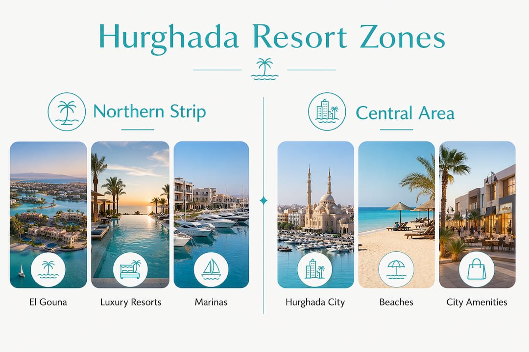
Resort areas are distributed across three main zones: the northern strip near El Gouna, the central area around Hurghada's old town (Ad Dahar) and the marina, and the southern corridor toward Sahl Hasheesh. Each zone has a different feel and price point.
Offshore islands and excursion planning
The Giftun Islands, including Big Giftun and Little Giftun, are the centerpiece of Hurghada's excursion economy. Most snorkeling and beach trips involve a boat ride of 30 to 60 minutes from the marina. The islands sit within a protected national park, which limits development and keeps the reefs in good condition.
- Book island excursions from the central marina area to minimize transfer time from your hotel.
- Check whether your boat goes to the Giftun Islands specifically, as some budget trips stop at closer, less impressive reef sites.
- Plan excursions for the morning. Wind picks up in the afternoon on the Red Sea, which makes the return journey rougher.
- Confirm that your excursion includes snorkeling equipment, as rental costs add up quickly at the island.
Pro Tip: The best beaches in Hurghada are mostly offshore rather than on the urban waterfront. The city's mainland beaches are functional but not spectacular. The real quality sand and coral is found at the Giftun Islands and at private resort beaches in Sahl Hasheesh.
The Red Sea Mountains and local climate
The Red Sea Mountains run parallel to the coast and sit directly west of Hurghada. They provide natural protection from desert winds and contribute to the dry, sunny climate that makes Hurghada a year-round destination. Rainfall is extremely rare. The mountains also create a visual backdrop that is visible from most beachfront hotels, adding to the scenic appeal of the area.
| Feature | Location relative to Hurghada | Tourism impact |
|---|---|---|
| Giftun Islands | East, offshore | Primary snorkeling and beach excursion site |
| Red Sea Mountains | West | Shapes climate, limits inland development |
| Safaga | South, ~30 km | Alternative dive sites, quieter beaches |
| El Gouna | North, ~23 km | Upscale resort town, day trip destination |
How far is Hurghada from major cities and landmarks?
Distance and travel time are practical concerns that affect every itinerary. Hurghada is not isolated, but it is not close to Egypt's main population centers either.
- Cairo to Hurghada: The driving distance is about 455 km, with a typical travel time of 5 to 7 hours by road. The route passes through the Eastern Desert and is well maintained. Many travelers prefer to fly, as Hurghada International Airport receives direct flights from Cairo in under an hour.
- Luxor to Hurghada: The distance is roughly 290 km by road, taking approximately 3 to 4 hours. This route crosses the Eastern Desert and offers access to the Nile Valley's ancient sites. Combining Luxor and Hurghada in one trip is a popular choice.
- Marsa Alam to Hurghada: The drive south covers approximately 220 km and takes around 2.5 to 3 hours on the coastal highway.
- Sharm El Sheikh to Hurghada: Direct road travel is not practical. The most common option is a ferry across the Gulf of Suez, which takes around 90 minutes, or a flight.
Hurghada International Airport serves both international and domestic routes. Direct flights connect Hurghada to major European cities including London, Frankfurt, and Amsterdam, as well as to Cairo and other Egyptian destinations. For travelers arriving from outside Egypt, flying directly into Hurghada is almost always the fastest option.
Key Takeaways
Hurghada is the capital of Egypt's Red Sea Governorate, stretching 40 km along the coast with the Red Sea Mountains to the west and the Giftun Islands offshore to the east.
| Point | Details |
|---|---|
| Geographic position | Hurghada sits at 27.26°N, 33.81°E, midway along Egypt's northern Red Sea coast. |
| City length matters | The 40 km coastal strip means transfers between resort zones can take 30–45 minutes. |
| Offshore islands | The Giftun Islands are the main excursion destination, reached by a 30–60 minute boat ride. |
| Distance from Cairo | Cairo is approximately 455 km away, with a 5–7 hour drive or under one hour by plane. |
| Regional context | Hurghada is one of several Red Sea cities; El Gouna, Sahl Hasheesh, and Marsa Alam are nearby alternatives. |
Padsabroad's take on reading Hurghada's geography before you book
Most travelers arrive in Hurghada with a vague sense of where it is. They know it is on the Red Sea. What they do not know is that the city is long, the best beaches are offshore, and the resort they booked might be 40 minutes from the marina where their boat trip departs.
The single most useful thing you can do before booking is look at a Hurghada Red Sea map and identify which zone your hotel sits in. Northern hotels near El Gouna are great if you want a quieter, upscale experience. Central hotels near the marina give you the fastest access to island excursions. Southern hotels near Sahl Hasheesh offer the best private beach access but require more planning for day trips.
Many travelers also confuse Hurghada with the Red Sea as a whole. The Red Sea coastline runs for hundreds of kilometers. Hurghada is one city on that coast. Sharm El Sheikh is on a completely different body of water, separated by the Gulf of Suez. Marsa Alam is a two-and-a-half-hour drive south. Treating Hurghada as a base for the entire Red Sea region works well for the northern section, but not for everything.
The offshore island geometry is also worth understanding before you arrive. Most activities involve boat travel, not walking to a beach. Budget time for that. A full-day island trip realistically takes eight hours from hotel departure to return. Plan your schedule around that reality, not around the idea that the sea is just outside your door.
— Padsabroad
Padsabroad's Red Sea property and travel resources
Travelers who fall in love with Hurghada often start asking a different question: what would it cost to own here?

Padsabroad specializes in overseas property on the Red Sea coast, with listings across Hurghada, El Gouna, Sahl Hasheesh, Soma Bay, Marsa Alam, and Port Ghalib. The team brings UK and Egypt-based expertise to every transaction, helping international buyers understand the local market, legal process, and geographic differences between resort zones. Whether you are researching a holiday home or a long-term investment, Padsabroad's local knowledge of the Hurghada property market gives you a clear starting point. Visit padsabroad.info to browse current listings and connect with the team.
FAQ
Where exactly is Hurghada located in Egypt?
Hurghada is located on Egypt's Red Sea coast at approximately 27.26°N, 33.81°E, serving as the capital of the Red Sea Governorate. It sits between Ras Gharib to the north and Safaga to the south.
How long is Hurghada's coastline?
Hurghada stretches close to 40 km along the Red Sea shoreline. That length means the northern and southern ends of the city are genuinely far apart, which affects hotel choice and transfer planning.
Is Hurghada the same as the Red Sea?
Hurghada is a city on the Red Sea coast, not the entire Red Sea region. The Egyptian Red Sea coastline runs from the Gulf of Suez in the north to the Sudanese border in the south, with multiple resort cities along the way.
How far is Hurghada from Cairo?
The driving distance from Cairo to Hurghada is approximately 455 km, taking 5 to 7 hours by road. Hurghada International Airport also offers flights from Cairo in under one hour.
What are the best beaches in Hurghada?
The best beaches near Hurghada are mostly offshore at the Giftun Islands, reached by a 30 to 60 minute boat ride. Private resort beaches in Sahl Hasheesh, about 18 km south of the city center, are also among the top options.